
How to Integrate AI Utility Inspections With the Systems You Already Run
AI inspection findings only count when they reach the EAM work order, the GIS layer, and the reliability model. Here are the four data agreements that make that happen - and the reason most integrations fail before the first API call.
- Integration fails at the data layer before the API layer. GPS misassociation alone drives 35% of delivered-imagery rework - the image was fine, it was attached to the wrong structure (State of Utility Drone Inspections, 2026).
- The Asset-Record Contract - identity, location, taxonomy, evidence - is the four-agreement checklist that decides whether findings can flow into Maximo, SAP, ArcGIS, and outage tools.
- Your EAM does not need another dashboard. It needs work-order-ready findings keyed to the asset IDs it already holds, with the photo evidence attached.
- Multi-contractor programs stand or fall on one capture and metadata standard: roughly 30% of ad-hoc imagery is rejected before analysis even starts.
- Security travels with the data. RBAC, audit logging, and an audited posture like SOC 2 are integration requirements, not add-ons.
Every AI inspection demo ends the same way: a map, some bounding boxes, a dashboard. Then the buyer asks the only question that matters - how does this reach the planner who cuts the work order - and the room gets quieter. This guide answers that question the way an asset program has to: system by system, and data field by data field.
What does it mean to integrate AI utility inspections?
Integration means inspection findings land, with their evidence, in the systems that already run your utility - not in one more viewer your planners have to check. Three system families matter, and each one expects something different from inspection AI.
| System family | What it holds | What inspection AI owes it |
|---|---|---|
| EAM / CMMS (Maximo, SAP) | The asset registry and the work-order queue | Work-order-ready findings keyed to existing asset IDs, with severity and photo evidence |
| GIS (Esri ArcGIS) | Location truth for every structure | Findings pinned to verified structures, publishable as a condition layer |
| OMS / reliability analytics | Outage history and risk models | Validated risk signals - reviewed findings with severity, not raw detections |
Most utilities already own strong tools in the first two families. The utility software stack is not missing a system - it is missing the connective layer that turns imagery into records those systems can act on. That layer is what you are actually buying when you buy inspection AI.
Why do AI inspection integrations fail?
They fail at the data layer before the API layer. Across the contracts analyzed in Detect's State of Utility Drone Inspections 2026, 15-25% of delivered imagery needs remediation before utility QA or analytics can use it. The largest single cause has nothing to do with software connectors.
35% of imagery rework traces to GPS misassociation - structure proximity confuses auto-tagging, and the image files against the wrong structure. The photo was fine. The API worked. The record is still wrong.
Source: State of Utility Drone Inspections, Detect, 2026.
Follow that error downstream and the damage compounds. A defect filed against structure 214 instead of 215 creates a work order that sends a crew to the wrong pole. A clean image of the wrong structure tells your GIS the wrong asset is healthy. One misfiled image can corrupt two records at once, and neither system knows it.
The rest of the breakdown follows the same pattern. Missing component coverage - the angle that was never flown - accounts for 30% of rework. Resolution and focus issues take 18%. Metadata format mismatches, where the capture carries fields the receiving system cannot read, take another 12%. Every one of these is settled in the field and in the data spec, long before an integration engineer touches anything. The workflow choices that cut rework from the 15-25% range to 3-7% are the same choices that make integration possible.
What is the Asset-Record Contract?
The Asset-Record Contract is a four-part agreement between your inspection program and your systems of record. Settle all four and integration becomes plumbing. Skip one and no connector can save you.
1. Identity - one asset ID namespace. The platform keeps one record per structure, keyed to the same IDs your EAM and GIS registry already share. This sounds obvious. It is also the most commonly skipped step. Inspection data organized as a folder per flight cannot be reconciled with a registry organized as a record per asset - someone ends up re-keying thousands of findings by hand.
2. Location - verified association. Every image is checked against its structure before analysis, because auto-tagging fails exactly where transmission assets live: parallel circuits, tight corridors, structures a rotor-diameter apart. Verification is the difference between a condition record and a liability.
3. Taxonomy - defect classes map to work-order codes. Detect's transmission catalog, for example, runs to 258 defect types across 19 component classes. The count matters less than the mapping: each class the platform reports has to land on a problem code your planners already use. If the mapping lives in a spreadsheet a contractor maintains, it is not integration - it is a dependency.
4. Evidence - findings stay auditable. The image, the reviewer, and the timestamp travel with every finding into the work order. When a regulator, an insurer, or a warranty claim asks why you replaced that cross-arm - or why you did not - the answer is attached to the record. Not buried in a photographer's archive.
The contract is also the boundary between systems. The image-to-work-order workflow describes how findings move; the contract describes what they must carry to survive the trip.
How does AI inspection software integrate with Maximo, SAP, and Esri ArcGIS?
By writing to each system in its own terms - not by asking your planners to live in another tab. What that looks like, system by system:
EAM and CMMS (IBM Maximo, SAP). The deliverable is a work-order-ready record: asset ID, problem code, severity, recommended action, and a link to the reviewed evidence. Delivered that way, a finding becomes a work order without re-keying, and closes the loop when the repair is logged. Delivered as a PDF report, it becomes a meeting.
GIS (Esri ArcGIS). Findings publish as a condition layer against the structure features you already maintain. A reliability engineer sees defect severity along a corridor the same way they see vegetation or outage history. The GIS stays the location truth; the inspection platform feeds it, never forks it.
OMS and reliability analytics. What these models need is scarcer than data: validated risk signals. Raw AI detections carry false positives, and a risk model fed on unreviewed detections learns noise. This is where the Hybrid AI + Expert Review model earns its keep. The AI screens the volume and experts confirm what is real. Only validated findings cross into the systems that rank risk and schedule spend.
Ask one question in every platform demo: "Show me a finding arriving in our EAM." If the answer involves a CSV download, you are not looking at an integration - you are looking at a re-keying step with an audit gap where the evidence used to be.
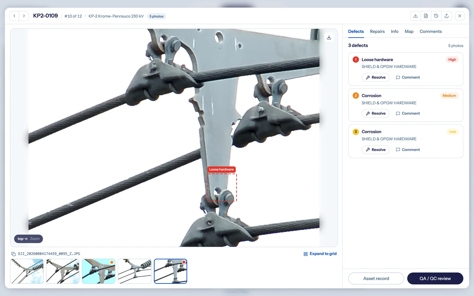
The record integration depends on: one structure, its findings, severity, review status, and evidence in a single view. Shown in a DetectOS demo environment.
How do inspection findings become work orders?
Through a pipeline that starts well before the software: registry first, standard second, quality gate third, review fourth, delivery last. Here is the sequence that keeps each step honest.
- Align the asset registry first. Agree on the structure ID namespace with your EAM and GIS owners before the first flight. Every later step keys on it.
- Write the capture and metadata standard into the contract. Shot list per structure type, resolution floor, and the metadata fields your systems require - so compliance is checkable, not aspirational.
- Gate quality at ingest. Score every image for association and assessability before analysis. Catch the misfiled and the unusable while the crew is still in the field, not in the work-order queue.
- Validate findings with expert review. Let AI screen the volume; let experts confirm severity on what it flags. Only validated findings earn the right to become work orders.
- Deliver work-order-ready records - and measure the lag. Track time from capture to work order as a program metric. It is the honest test of whether integration exists.
Scale is what makes the pipeline non-negotiable. On one newly commissioned ~250-mile HVDC intertie, a 30-day campaign put 122,714 images through this sequence with a three-person team. The AI flagged 1,270 for review. One validated finding - a clevis bolt backed off, its cotter key missing - became a work order cleared in 120 minutes of field time, in the line's first operating season. The operator valued the averted forced outage at more than $1M (Detect Data Quality Program, 2026). None of that reaches a planner if the finding dies in a file share.
Judge the output end of the pipeline the way you would judge any deliverable. Run the seven checks before you trust a platform's findings, and make passing them a condition of the integration going live.
How do you centralize multi-contractor inspection data?
One standard, one quality gate, one record per structure - no matter who flew, or with what. Utilities increasingly take imagery from several drone service providers, their own crews, helicopter patrols, and ground capture methods in the same season. Without a shared standard, each source arrives in its own format, keyed its own way. Roughly 30% of ad-hoc imagery gets rejected before analysis even starts (State of Utility Drone Inspections, 2026).
The fix is contractual, then technical. Put the capture standard and the metadata spec in every vendor agreement. Run every source through the same ingest gate. Key everything to the same registry. Contractors benefit as much as you do: a DSP delivering to a published standard cuts its own rework from the 15-25% range to 3-7% within two campaigns. And a contractor whose data flows straight into your systems is a contractor you rehire.
What security does an integrated inspection platform need?
The same controls as anything else that writes toward your EAM. A finding that triggers a work order is an operational record. The platform that produces it needs role-based access control scoped by team and contractor, audit logging on every review decision, and an independently audited posture. Detect, for example, holds SOC 2 Type II compliance. In multi-contractor programs, RBAC is also a business requirement: each DSP sees its own deliveries and nothing else, while your team sees the whole network.
Audit logging closes the loop the evidence agreement opens. Who uploaded the image, who reviewed the finding, who changed its severity, when it entered the work-order queue. An integrated record answers those questions in seconds, or fails its first audit.
How should you evaluate integration capability?
With specific questions and visible proof, in the demo, on your own asset structure. Six that separate integration from marketing:
| Ask | What good looks like |
|---|---|
| How do findings key to our asset registry? | Your structure IDs, imported before the pilot - not a proprietary numbering scheme |
| How is image-to-structure association verified? | A checked step with a quality score, before analysis - not trust in GPS auto-tags |
| How do defect classes reach our problem codes? | A maintained mapping in the platform, reviewed with your planners |
| What does a finding look like in our EAM? | A work-order-ready record with evidence attached - shown live, not described |
| Who can see and change what? | RBAC by role and contractor, with an audit log you can inspect |
| What is the capture-to-work-order lag? | A measured number the vendor will commit to tracking with you |
Integration is one criterion among several when scoring AI grid inspection platforms - but it is the one your planners will live with every day after the pilot ends.
The bottom line
To integrate AI utility inspections, settle the data before the software: one identity namespace, verified association, a mapped taxonomy, and evidence that travels. Platforms that honor that contract disappear into your existing workflow - findings arrive as work orders in Maximo or SAP, condition layers in ArcGIS, validated risk signals in your reliability models. Platforms that skip it produce one more dashboard, and dashboards do not fix structures.
That is the standard Detect builds DetectOS against: decision-grade findings from every image, delivered into the systems your network already runs on.
See your own imagery arrive work-order-ready
Send us a sample from your last inspection campaign. DetectOS will quality-gate it, run analysis with expert review, and show you findings keyed to your structures - ready for the systems you already run.
Book a free audit →