
5 Data Quality Failures Costing DSPs Millions in Utility Inspection Rework
Updated July 2026 with rework and capture-quality findings from Detect’s State of Utility Drone Inspections 2026 report.
Here’s a scene that plays out every week in this industry:
A DSP wraps a 200-structure transmission inspection. Weather cooperated. The pilots were sharp. Data was delivered on time. Then the email arrives - rejection notices on a third of the structures. Missing angles. Insufficient resolution on insulators. Metadata that doesn’t match. The contract is fixed-fee. The reflight is on you.
If you run a drone service provider on utility contracts, you know this story. And the frustrating part isn’t the single rejection. It’s the pattern. Different pilots, different lines, same result.
The instinct is to blame the pilot. But after working on both sides of the inspection transaction - with utilities who define “utility-grade” and DSPs who capture it - we can tell you: this almost never comes down to talent. It comes down to systems.
The data backs it up.
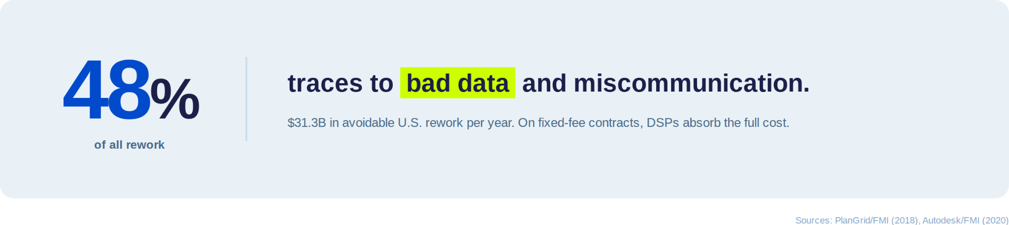
A landmark Autodesk/FMI study found bad data drove $88 billion in avoidable rework globally in 2020. A separate PlanGrid/FMI survey of 600 leaders found 48% of all U.S. construction rework traces to poor data and miscommunication - $31.3 billion per year.
Those figures come from the broader construction world. For DSPs on thin-margin, fixed-fee utility contracts, the same dynamics apply - but the consequences hit harder and faster. Here are the five specific failures we see driving most rejected inspection data, what they cost, and what the highest-performing DSPs do differently.
Key Takeaways for Drone Service Operators:
- It's not your pilots. You keep replacing people when the real problem is you never gave them a system. Different pilots, different lines, same rejections - that's a process failure, not talent.
- Your QA process is a time bomb. For every day your crew flies, someone spends 3–4 days sorting images at a desk. By the time they find the problems, the crew is gone and the reflight is on your dime.
- Utilities aren't rejecting your images. They're rejecting your format. The photos might be sharp. But if the metadata doesn't match and it lands as a folder instead of structured GIS-ready data - it's a rejection.
- GPS lies near high-voltage lines. One wrong structure tag and the entire batch gets kicked back. This boring-sounding problem is the single most expensive failure in the pipeline.
- A 10% rework rate doesn't cost you 10%. It costs you the reflight, the remobilization, the weather delay, the opportunity cost - and the vendor scorecard hit that follows you into next year's bid.
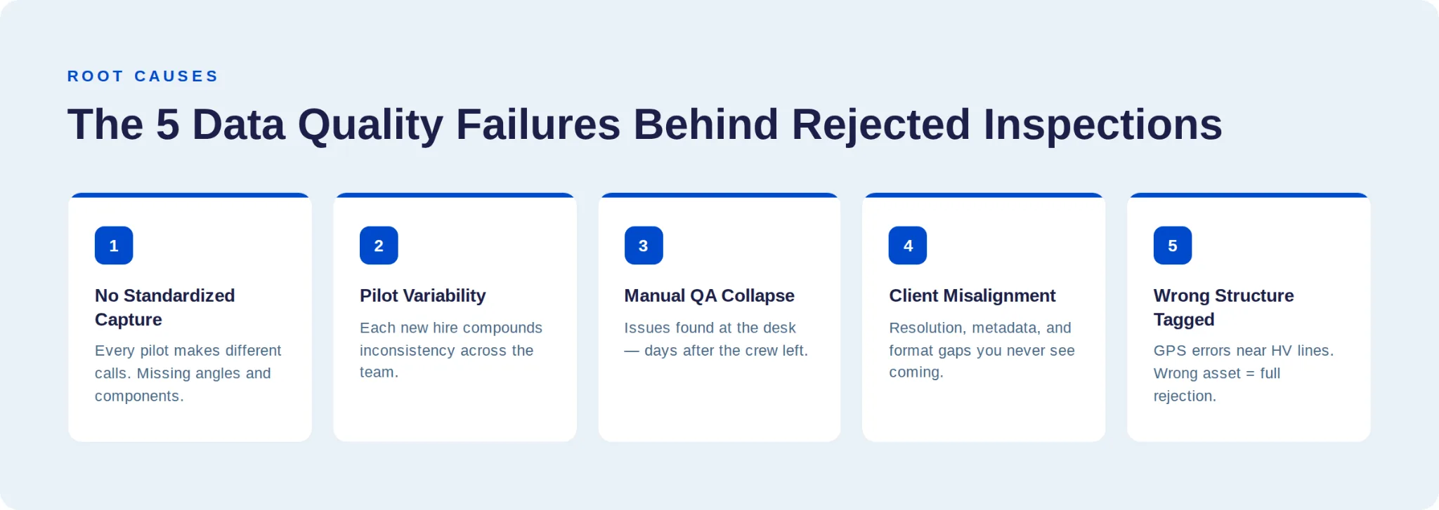
The 5 Data Quality Failures Behind Rejected Utility Inspections
#1: No Standardized Drone Inspection Data Capture Methodology
Why This Happens
Without predefined, structure-specific shot requirements, every pilot makes their own judgment calls - what angles to capture, how close to fly, which components to prioritize. The images usually look fine on a laptop. But they don’t meet the structured requirements utility asset managers need for defect identification, AI analysis, and GIS integration.
A lattice tower, an H-frame, and a monopole each demand completely different flight paths, angle coverage, and component focus. Utility engineers expect imagery of insulators, conductor hardware, bolted connections, splices, vibration dampers, and grounding systems. A “fly around and shoot” approach - no matter how skilled the pilot - routinely misses components.
A study in the ISPRS Journal of Photogrammetry and Remote Sensing found that close-range UAV images frequently suffer from blurriness, improper exposure, limited coverage, and insufficient resolution - problems that directly compromise downstream damage identification.
How to Fix It
3D digital shot sheets specify every required angle, position, and camera setting for each structure type. Your newest pilot captures the same data as your most experienced one. The standard becomes the system - not a PDF that gets skimmed during onboarding.
The fix for inconsistent capture isn’t more training. It’s defining the standard digitally, then automating compliance with it.
#2: Pilot Variability That Compounds Every Time You Hire
The 5-Pilot Problem
Your first pilot is great - trained personally, knows the methodology, delivers clean data. Your fifth pilot? Different background, different instincts, different interpretation of “thorough coverage.” Multiply that across ten operators and the variability becomes a serious contract liability.

How to Fix It
Automated, self-guided missions solve this. GPS waypoint navigation, terrain-following, and automated orbits mean the drone executes the same methodology regardless of who’s holding the controller.
Adding pilots should scale your capacity, not your problems. If quality degrades every time you hire, you don’t have a talent issue. You have a process issue.
Automation doesn’t replace experienced pilots - it ensures every pilot performs like your best one.
#3: Manual QA That Collapses Under Volume
The Hidden Time Sink
Here’s the part of the workflow nobody budgets for: quality assurance. Industry operators report that sorting, naming, and organizing captured imagery can eat three to four full working days per flight day - before a single image gets analyzed.

The Real Cost Isn’t the Review Hours
It’s the timing. Blurry frames, coverage gaps, and exposure issues get discovered at the desk - days after the crew demobilized. Now you’re scheduling a reflight. Crew remobilization, weather windows, site access. All on your dime.
Quality assurance standards organizations are explicit: inspection protocols need repeatable procedures that maintain consistency across operators, projects, and time. Manual QA is inherently inconsistent. Two reviewers looking at the same dataset flag different things.
How to Fix It
Move QA to the field. Integrated quality checks that flag issues before the crew leaves the site break the remobilization cycle - the single most expensive pattern in DSP operations.
Every dollar spent on field QA saves ten dollars on reflight logistics. Move validation upstream.
#4: Misaligned Data Quality Expectations with the Utility Client
The Invisible Gap
The DSP thinks they delivered a solid dataset. The utility sees gaps they consider basic. This disconnect almost always comes down to three things:
- Resolution thresholds: Utilities require specific minimum pixel densities per component type.
- Metadata standards: GPS accuracy, timestamps, file naming conventions that match utility systems.
- Deliverable formats: Structured data that integrates with the utility’s GIS, CMMS, or AI analytics platform.
We see this gap daily through DetectOS. Utilities don’t just want images. They want structured, metadata-rich data that feeds directly into maintenance workflows and capital planning.
The PlanGrid/FMI study found the top drivers of rework from miscommunication are stakeholder unresponsiveness, inability to collaborate, and the lack of a shared data platform. For DSPs, this manifests as unclear scope documents, assumed standards, and deliverables that don’t match.
How to Fix It
Precision scoping through automated project onboarding establishes exact asset focus and shot expectations before the first flight. Your bids reflect actual requirements. Your margins are protected from day one.
If you’re guessing what the utility wants, you’re building rework into every contract.
#5: Photo-to-Structure Association Errors in Drone Inspections
The Problem Nobody Talks About
Mapping thousands of drone images to the correct asset sounds simple until you’re working near a 345kV transmission line where electromagnetic interference turns GPS coordinates into suggestions. Images get tagged to Structure 47 when they’re actually Structure 49. The utility rejects the entire batch.
Why It Matters More Than You Think
It doesn’t matter how sharp the image is or how perfect the angle coverage was. Wrong structure, wrong data, full rejection. This mundane-sounding failure is actually the highest-leverage improvement point in the entire inspection pipeline.
How to Fix It
Structured, georeferenced capture from the point of acquisition - where every image is precisely associated with the correct asset and component before it leaves the field. Our inspection process builds this in from the start.
Photo-to-structure association errors are invisible until the rejection notice arrives. Fix them at capture, not in post-processing.
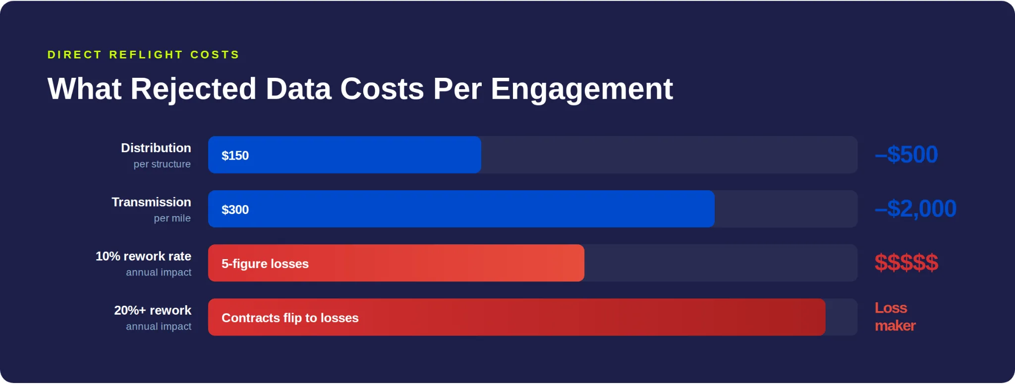
What These 5 Data Failures Actually Cost Your DSP
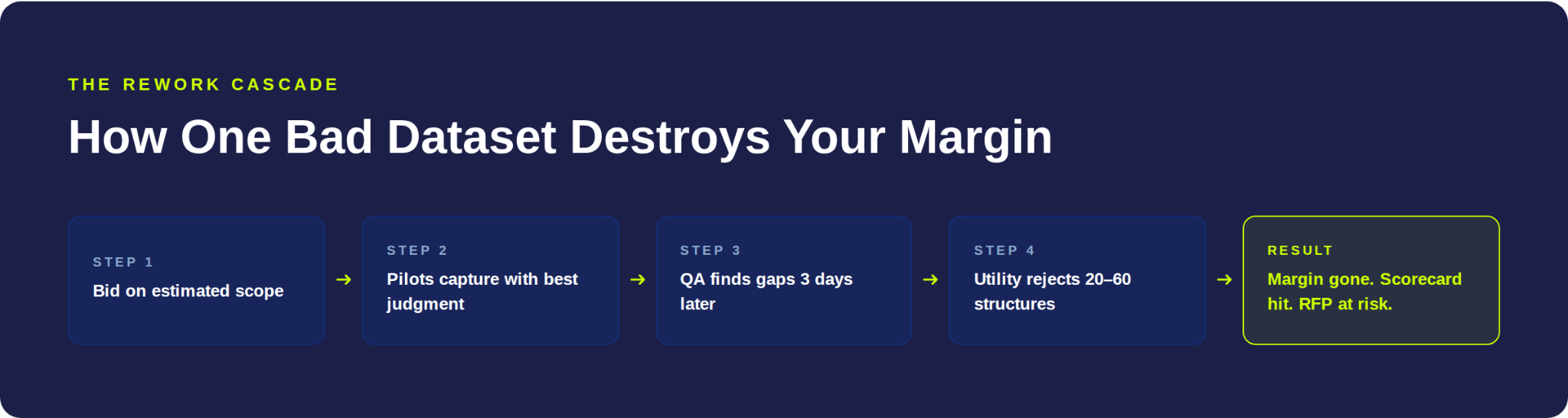
The Rework Cascade on Fixed-Fee Utility Contracts
At typical utility inspection rates of $150–$500 per structure for distribution and $300–$2,000 per mile for transmission, even a 10% rework rate creates five-figure annual losses. At 20%+, it flips profitable contracts into loss-makers.
Here’s how the cascade plays out:
- You bid based on estimated scope. Without standardized shot sheets, that estimate is a guess.
- You capture. Pilots make reasonable calls - but they’re not aligned with utility-specific requirements.
- QA happens at the desk. Three days later, someone discovers coverage gaps.
- The utility rejects. 20, 40, 60 structures get flagged.
- You reflight at your cost. Travel, crew time, equipment, opportunity cost. All absorbed by you.
- Your margin evaporates. And the utility logs the rejection against your vendor scorecard for next year’s RFP.
The Broader Industry Numbers
Detect’s own State of Utility Drone Inspections 2026 report puts inspection-specific numbers on the same pattern: 15-25% of delivered imagery gets reworked on a typical utility program, GPS misassociation alone accounts for 35% of that rework, and roughly 30% of ad-hoc imagery - photos captured without a shot plan - is rejected outright. DSPs that standardize capture cut rework to 3-7% within two campaigns.
According to research compiled by Buildern, rework contributes to an average of 52% of total cost growth in construction projects. The Construction Industry Institute found direct rework costs average 5% of total project value - and that companies achieving rework rates of 2% or less realize the savings as direct profit margin improvement.
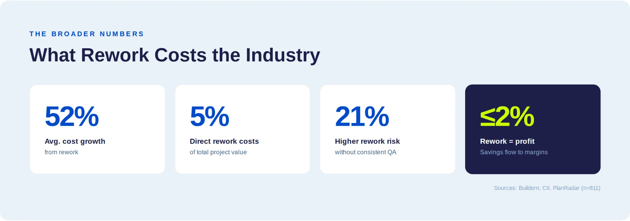
A PlanRadar analysis of 811 construction professionals found that firms without consistent QA standards are 21% more likely to experience avoidable rework, 50% more likely to face warranty exposure, and 23% more likely to have subcontractor disputes.
RUN YOUR OWN NUMBERS
A DSP running 200 monthly flights with a 15% rework rate and $800 average reflight cost loses ~$288,000 annually. Drop that rate to 2% and you save $249,600/year.
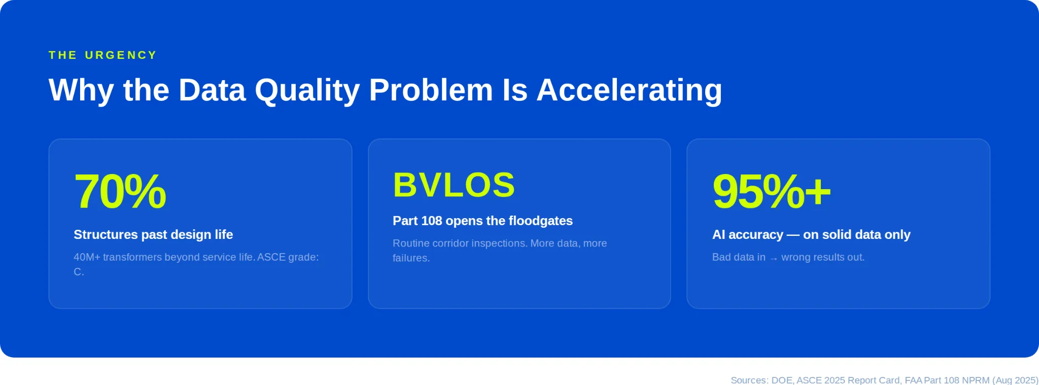
Why the Drone Inspection Data Quality Problem Is Accelerating
The Grid Is Aging Faster Than It’s Being Replaced
70% of transmission structures have exceeded their design life. Over 40 million distribution transformers are past intended service life. The ASCE’s 2025 Report Card rated U.S. infrastructure at a C. That means more inspections, not fewer.
Regulations Are Opening the Floodgates
The FAA’s August 2025 BVLOS NPRM (Part 108) will enable routine corridor inspections without per-mission waiver approvals. More drone flights, more data, more opportunities for quality failures.
AI Needs Better Data, Not More Data
AI-powered defect detection achieves 95%+ accuracy - when the data foundation is solid. Georgia Power’s drone program discovered 5,174 safety issues traditional methods missed, with 60% cost reduction. But AI fed bad data doesn’t give you bad results. It gives you wrong results. And wrong is worse than none.
The Stakes Are Existential
In 2018, a single failed suspension hook on a PG&E transmission line caused the Camp Fire - 85 lives lost, $16 billion in damage. The cause: inadequate inspections. Your data exists in that environment.
Every industry trend - aging grid, BVLOS expansion, AI adoption - is increasing the volume and stakes of drone inspections simultaneously.
How Top DSPs Are Fixing All 5 Data Quality Failures
The five failures aren’t five separate problems. They’re symptoms of one gap: no standardized operating system for field capture. Fix the system, and every failure resolves.
Standardize What “Utility-Grade” Means for Your Operation
Solves: Failure #1 (methodology) and #4 (misalignment)
3D digital shot sheets define every required angle, position, and camera setting per structure type. When every mission starts from the same specification, the gap between what you capture and what the utility expects disappears.
Automate Capture and QA Together
Solves: Failure #2 (pilot variability), #3 (manual QA), and #5 (association errors)
Flight automation handles execution - self-guided missions with predefined routes. Integrated field QA handles validation - flagging gaps, exposure issues, and missing components before the crew leaves. Together, they break the remobilization cycle.
The industry evidence is clear: modern automation enables consistent data quality regardless of individual pilot skill level.
Build Pilot Expertise in Utility Infrastructure
Amplifies all five fixes
Technology handles methodology and QA. But pilots who understand structure identification, component-level awareness, and standardized hardware assessment capture data that’s not just technically compliant - it’s operationally valuable.

Scope with Precision to Protect Margins
Prevents the cascade before it starts
Automated project onboarding establishes exact asset focus and shot expectations upfront. Your bids reflect actual scope. Your margins survive contact with reality.
The goal isn’t to replace experienced pilots. It’s to turn every pilot into your best pilot - with systems that make guesswork unnecessary.
What Your Utility Client Actually Means by “Utility-Grade Data”
We hear DSPs use this phrase constantly. Here’s the concrete standard, based on what we see utilities evaluate through DetectOS:
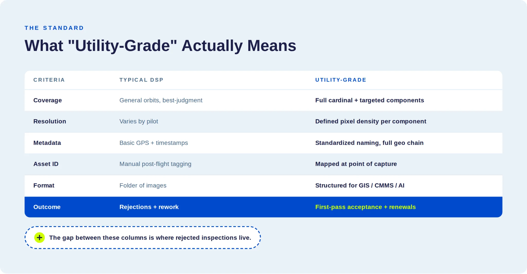
The gap between those columns is where your rejected inspections live. Close it systematically and the rework stops.
Capture sharpness is the dividing line. On the 258-type defect catalog DetectOS assesses against, sharp images are 100% assessable, soft images are 69% assessable, and blurry images just 7%. “Utility-grade” starts with capture quality, not camera specs.
The DSPs That Fix This Win. The Rest Get Replaced.
The utility inspection market is consolidating around operators who can deliver consistent, utility-grade data at scale. The DSPs gaining market share in 2026 have stopped treating data capture as a commodity and started treating it as a precision discipline.
They bid accurately because they scope with defined standards. They protect margins because they’ve eliminated rework at the source. They win renewals because utilities trust their data. And they scale confidently because adding pilots doesn’t degrade quality.
The DSP that captures utility-grade data from day one doesn’t compete on price. They compete on trust. In this market, trust is the only advantage that compounds.
Ready to eliminate rework and protect your margins?
The Detect Pilot Partner Program is a self-guided, automated capture system built for DSPs on utility contracts. It includes 3D digital shot sheets, flight automation with integrated field QA, project onboard automation, and a curriculum that builds real infrastructure expertise across your pilot team.
→ Start Your Free Program Assessment
Related reading: understand how data quality drives AI asset inspection ROI and why AI inspections miss defects.
