
U.S. Drone Pilot Certification Platforms Compared: What Utility Survey Work Requires
A Part 107 certificate proves a pilot can fly legally. It says nothing about whether the imagery coming back can be used. Here is how the certification tiers compare, where field variability actually comes from, and what to require before the first structure is flown.
U.S. drone pilot certifications stack in three tiers: legal to fly (FAA Part 107), safe to operate (operator-safety programs), and qualified to deliver (a capture standard with a flown verification). Only the third tier controls field variability. The drone pilot certification and survey workflow tools worth requiring are the ones that certify the deliverable, not just the flight.
- Part 107 is the floor, not the standard. It certifies airspace and regulations. It does not test coverage, camera settings, or whether an image is tied to the right structure.
- 53% of imagery rework is pilot-dependent. Missing component coverage (30%), resolution and focus (18%), and lighting go/no-go calls (5%) - the causes training fixes (Detect, State of Utility Drone Inspections 2026).
- Compare platforms by tier, not by brand. Legal to fly, safe to operate, qualified to deliver - three different questions, and most comparisons only answer the first.
- The shot sheet is the certification. A written standard per structure type, flown once as a verification, moves consistency out of a pilot's habits and into the program.
- Standardized capture cuts rework from 15-25% to 3-7% within two campaigns - the number that makes field variability a budget line.
- Write the requirement as an outcome. Named programs are ways to meet it; the acceptance criteria are what protect your data.
Every utility operations leader has seen the same deliverable. A certified pilot, a compliant flight, a folder of sharp photographs - and a quarter of them unusable. The angle that would have shown the cotter key was never flown. The settings drifted between structures. Two crews photographed the same corridor and produced two records nobody can compare.
Nothing about that outcome breaks a rule. Part 107 was satisfied. The problem is that the certification being checked answers a different question from the one the program is asking. This guide compares the certification paths a U.S. utility can require, sorted by which question each one answers.
What does a drone pilot certification actually certify?
FAA Part 107 certifies that a remote pilot understands airspace, weather, regulations, and safe operation. The certificate is earned through an aeronautical knowledge test and kept current with recurrent training every 24 months. It does not test imaging, coverage, data association, or any survey deliverable (FAA, 14 CFR Part 107).
That scope is by design - Part 107 is a safety rule. Flight stays within visual line of sight unless the operator holds a Part 107 waiver, and the BVLOS rule the FAA proposed in August 2025 addresses where aircraft may fly, not what the camera must capture. A pilot can hold a spotless certificate and still return imagery a utility cannot assess.
How do U.S. drone certification platforms compare for utility survey work?
By tier. Detect groups every U.S. certification path into the Certification Stack: three tiers that answer three different questions, each necessary and none sufficient on its own. The same three tiers apply north of the border under Transport Canada's rules; how a Canadian program writes them into procedure is the subject of the beginner's guide to utility drone SOPs in Canada.
| Tier | Examples | What it proves | What it leaves open | Effect on field variability |
|---|---|---|---|---|
| 1. Legal to fly | FAA Part 107 certificate; prep courses such as Pilot Institute, UAV Coach, DARTdrones | Airspace, regulations, weather, operating rules | Everything about the deliverable | None - two certified pilots can return incomparable imagery |
| 2. Safe to operate | AUVSI Trusted Operator Program; manufacturer flight training; safety prequalification (ISNetworld, Avetta) alongside insurance | Risk management, aircraft handling, documented procedures | Capture quality, coverage, association | Indirect - fewer incidents, same data variance |
| 3. Qualified to deliver | A utility capture standard with a flown verification - Detect's Data Quality Program, or a utility's own EPRI-derived spec with a check flight | Required angles per structure type, a camera-settings floor, QA before demob, association to the asset | Nothing the analysis needs | Direct - the standard lives in the program, not the pilot |
| Adjacent: mapping-software certification | Vendor courses for photogrammetry tools such as Pix4D and DroneDeploy | Proficiency with a specific drone mapping software | Whether the input imagery was captured consistently | Low - good processing cannot repair inconsistent capture |
Read the table from the bottom up and the pattern is plain: the tiers utilities most often check are the ones with the least effect on the data. Tier 1 and Tier 2 are gates - require them, verify them, and move on. Tier 3 is where the buying decision lives.
Why doesn't certified-to-fly mean consistent field data?
Because more than half of imagery rework traces to decisions Part 107 never tests. In Detect's analysis across utility inspection programs, missing component coverage accounts for 30% of delivered-imagery rework, resolution and focus issues 18%, and lighting and weather go/no-go calls 5%. Those three causes are pilot judgment and pilot settings - 53% of rework, from decisions made at the structure (Detect, State of Utility Drone Inspections, 2026).
The other 47% is system-side: GPS misassociation (35%), where structure proximity confuses auto-tagging, and metadata format mismatches (12%), where each utility specifies differently. Those are fixed by tooling and contracts. The pilot-dependent half is fixed by one thing only - a standard the pilot has demonstrated, not just read.
The cost is not abstract. Across the contracts in the same research, 15-25% of delivered imagery needs remediation before utility QA or analytics can use it, and roughly 30% of ad-hoc imagery is rejected outright. Programs that adopt a standardized capture workflow bring the rework rate down to 3-7% within two campaigns. The five data quality failures behind those rejections are the same five a capture certification exists to close.
53% of delivered-imagery rework comes from pilot judgment and pilot settings - missing component coverage, resolution and focus, and go/no-go calls. No Part 107 question covers any of them.
Source: Detect, State of Utility Drone Inspections, 2026.
What should a repeatable aerial survey process include?
Five things, in the order they fail: a shot sheet per structure type, a camera-settings floor, an association check, QA before demobilization, and a metadata standard the receiving system can read. Drone surveying workflows that carry all five produce imagery that can be compared cycle over cycle; workflows that carry fewer produce photographs.
A shot sheet per structure type. Lattice towers, monopoles, H-frames, and wood poles each have their own required angles and components. The wooden H-frame audit that covered 96 structures in one field day with a 3-person crew flew four cardinal faces plus detailed imagery of the equipment at risk on every structure - the same sheet, every time, which is why the record was complete enough to fund a rebuild.
A camera-settings floor. Capture sharpness sets a ceiling on what analysis can see: in Detect's Data Quality Program analysis, sharp imagery left 100% of a 258-type defect catalog assessable, soft imagery 69%, and blurry imagery 7%. Settings that vary by pilot vary that ceiling by pilot.
An association check. Every image tied to a structure ID before it enters the record, so a sharp photo of the wrong pole cannot poison two condition histories.
QA before demob. Frames reviewed against the sheet on site. A coverage gap found in the truck costs a re-shoot; found in the office, it costs a re-mobilization.
A metadata standard. Naming, coordinate reference, and fields in the format the utility's systems expect. Drone mapping data consistency depends on it as much as on overlap and altitude - from flight to usable maps, the processing step can only be as consistent as the capture feeding it.
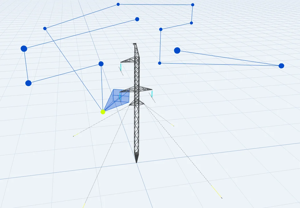
The shot sheet is the standard: required camera positions per structure type, the same on every job, for every pilot.
What does a utility-grade capture certification look like?
It has four properties: it is sensor-agnostic, it is built on a written standard per structure type, it ends in a flown verification rather than a written exam, and it grades imagery at ingest so rejects never reach an engineer. Detect's Data Quality Program is built to those four properties - free, open to any pilot with any drone, and the way into the Detect Partner Network.
The program runs as a course, a flown shot-sheet verification with any quadcopter, and a review call - no flight software to buy or learn. Its standard is inherited rather than invented: EPRI guidance, the utility's own spec, and the utility's defect taxonomy, expressed as shot sheets per structure type and a four-step operating pattern - calibrate, standardize, grade every image, validate (Detect Data Quality Program, 2026). How the program is taught, and why most DSPs hit a quality wall around their fifth pilot, is the subject of the drone pilot training built for utility inspection; what changed when it opened to any pilot with any drone is covered in the Partner Network announcement.
The outcome that matters to a utility is the one in the rework data: crews flying to a pre-built shot sheet and reviewing frames before demob re-fly 3-7% of deliverables, against 15-25% without one. That is the difference between a certification that describes a pilot and one that describes the data.
Which drone pilot certification and survey workflow tools should a utility require?
Require the legal and safety tiers as gates, then require the capture tier as an outcome: a documented standard, a flown verification per pilot, and acceptance criteria on the deliverable. Name accepted programs as ways to meet the outcome so the field stays open to any qualified provider.
In practice that is five contract lines. Part 107 and commercial insurance at intake. NDAA-compliant hardware where the network requires it - the NDAA compliance guide covers what that currently means for a fleet. A named capture standard with shot sheets per structure type, attached to the contract. A flown verification for each pilot before the first billable structure. Acceptance criteria written into the deliverable: assessability graded at ingest, association audited, metadata in the utility's format.
Those lines belong inside a broader scorecard. How utilities score drone vendors across binary gates and weighted criteria is its own discipline; the certification requirement is the line in that scorecard that decides whether the data arrives usable. The asset-owner side of the same standard - what to write into the photo spec itself - is laid out in the guide to utility photo data quality.
Before naming any program in a contract, put the same six questions to it. A partner that certifies the deliverable will have documents, reviewers, and numbers behind every answer.
- Show the written standard. A shot sheet per structure type on your asset classes - not a syllabus.
- Who reviews the flown verification, and against what pass criteria?
- What measured rework rate do certified pilots hold across recent campaigns?
- Is imagery graded for assessability at ingest, and what happens to rejects?
- Is the credential sensor-agnostic - does it survive a fleet transition?
- What does a pilot who fails the verification do next - retrain and re-fly, or bill anyway?
- Confirm the legal floor at intake. Part 107 certificate, current recurrent training, and commercial insurance for every pilot on the contract - a gate, not a score.
- Adopt one capture standard for every structure type. A shot sheet per structure type with required angles and a camera-settings floor, inherited from your spec, EPRI guidance, and your defect taxonomy.
- Require a flown verification per pilot. Each pilot flies the standard once and has the frames reviewed before their first billable structure.
- Put QA before demobilization in the contract. Frames are checked against the sheet on site. A gap costs a re-shoot on the spot, not a re-mobilization.
- Write acceptance criteria into the deliverable. Assessability graded at ingest, association audited, metadata in your format - rejects go back before analysis starts.
Certify the deliverable, not just the flight
The drone industry solved pilot certification years ago. Part 107 works; the prep platforms that teach it work. What utility survey programs still lack is the tier above it - a certification that describes the data a pilot returns rather than the aircraft they fly.
Until that tier is required, field variability is not a training problem or a software problem. It is a specification problem, and it is the utility's to fix. Require the standard, verify it in the air, grade it at ingest - and the certified pilot becomes a consistent one.
Grade your last campaign against the standard
Send Detect a recent inspection set. The free audit grades assessability and association image by image - the first measure of how much field variability your current certification requirements are letting through.
Book a free audit →