The Utility Drone Inspection Workflow to Eliminate Rework
Most drone service providers lose money on utility contracts before they even realize it. Rejected images, unpaid reflights, inconsistent capture across pilots, manual QA that doesn't scale — these problems compound silently until your margins on a fixed-fee contract are gone.
The root cause is almost never the pilot. It's the lack of a structured workflow between the DSP, the analytics partner, and the utility. When every pilot is improvising their own capture methodology, data variability is inevitable. When QA happens weeks after demobilization, rework is expensive. When nobody owns the handoff between raw imagery and utility-grade deliverables, the DSP absorbs the cost.
This is the workflow that fixes it. Nine steps, three parties, clear ownership at every stage — designed so your team captures utility-grade data the first time, every time.
The sensor package is a decision of its own - our guide to drone utility inspection compares what RGB, thermal, and LiDAR capture can each find before you build the flight plan.

Where Drone Inspection Rework Comes From
If you're flying utility inspection on fixed-fee contracts, you already know the pain points. But it's worth naming them because every one of them traces back to a specific gap in the workflow — and every gap has a fix.
- Inconsistent data capture across pilots. Your best pilot captures utility-grade imagery. Your fifth pilot doesn't. The utility rejects the batch. You eat the reflight. The problem isn't training — it's that each pilot interprets capture requirements differently because there's no standardized shot sheet that defines every angle, position, and camera setting.
- QA that happens too late. You demobilize. Two weeks later, the analytics team flags missing angles and out-of-focus images. Now you're sending a crew back to the site on your own dime. The fix isn't better QA — it's QA that runs in real time, before you leave the site.
- No clear scope boundary. Utility contracts are vague about where the DSP's job ends and the analysis starts. So you end up doing post-processing, image tagging, and reporting work that wasn't in your bid — or you deliver raw data and get blamed when the results are late.
- Manual workflows that can't scale. Manual flight planning, manual QA review, manual image organization. It works when you have two pilots flying one circuit. It breaks when you're running five crews across three utilities.
The workflow below solves each of these by giving every step a clear owner, automating the steps that kill your margins, and drawing a hard line between what you're responsible for and what the analytics partner handles.
9-Step Utility Drone Inspection Process
Steps 1–3: Before You Fly
The utility posts the job. Everything gets set up before a prop spins.
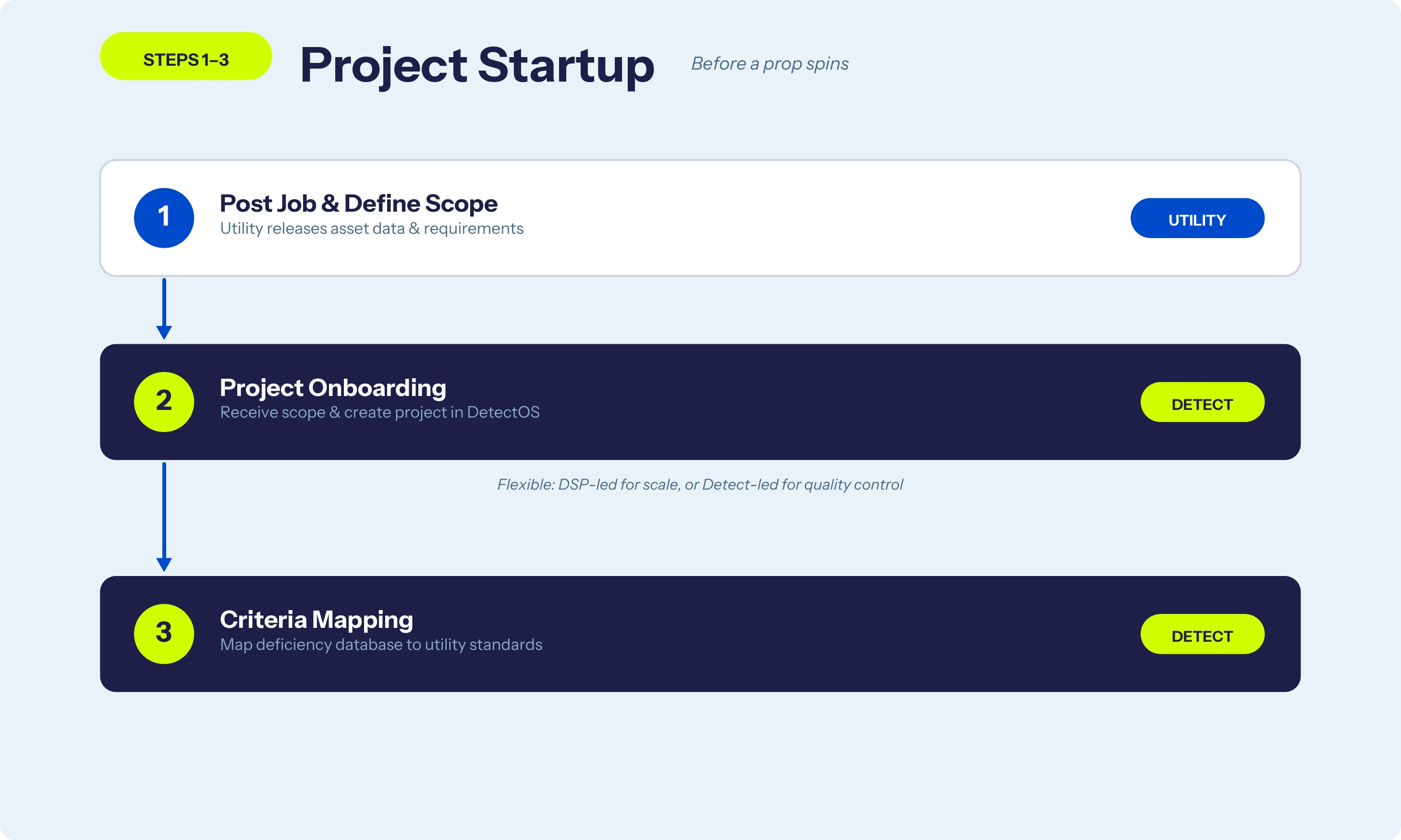
Step 1: The utility posts the job — asset data, inspection scope, requirements. This is the only input they provide until they receive results.
Step 2: Project onboarding — Detect receives the scope and builds the project in DetectOS. Asset mapping, timeline, pilot coordination. This can be DSP-led (you source and pursue utility work independently) or Detect-led (they manage the client). Flexible, depending on how you want to scale.
Step 3: Deficiency criteria mapping — Detect maps their database of deficiency types and severity levels to the utility's specific standards. This is the step that makes the final report immediately compatible with the utility's existing maintenance workflow. No translation layer. No reformatting. The utility gets results in their language.
Why this matters for your margins: Precise scoping in steps 2–3 means accurate bidding. You know exactly what's required before you price the job. No scope creep, no surprise rework on criteria you didn't know about.
Steps 4–6: Your Three Steps
This is where you come in — and where you leave. Review, fly, upload. That's the entire DSP scope.
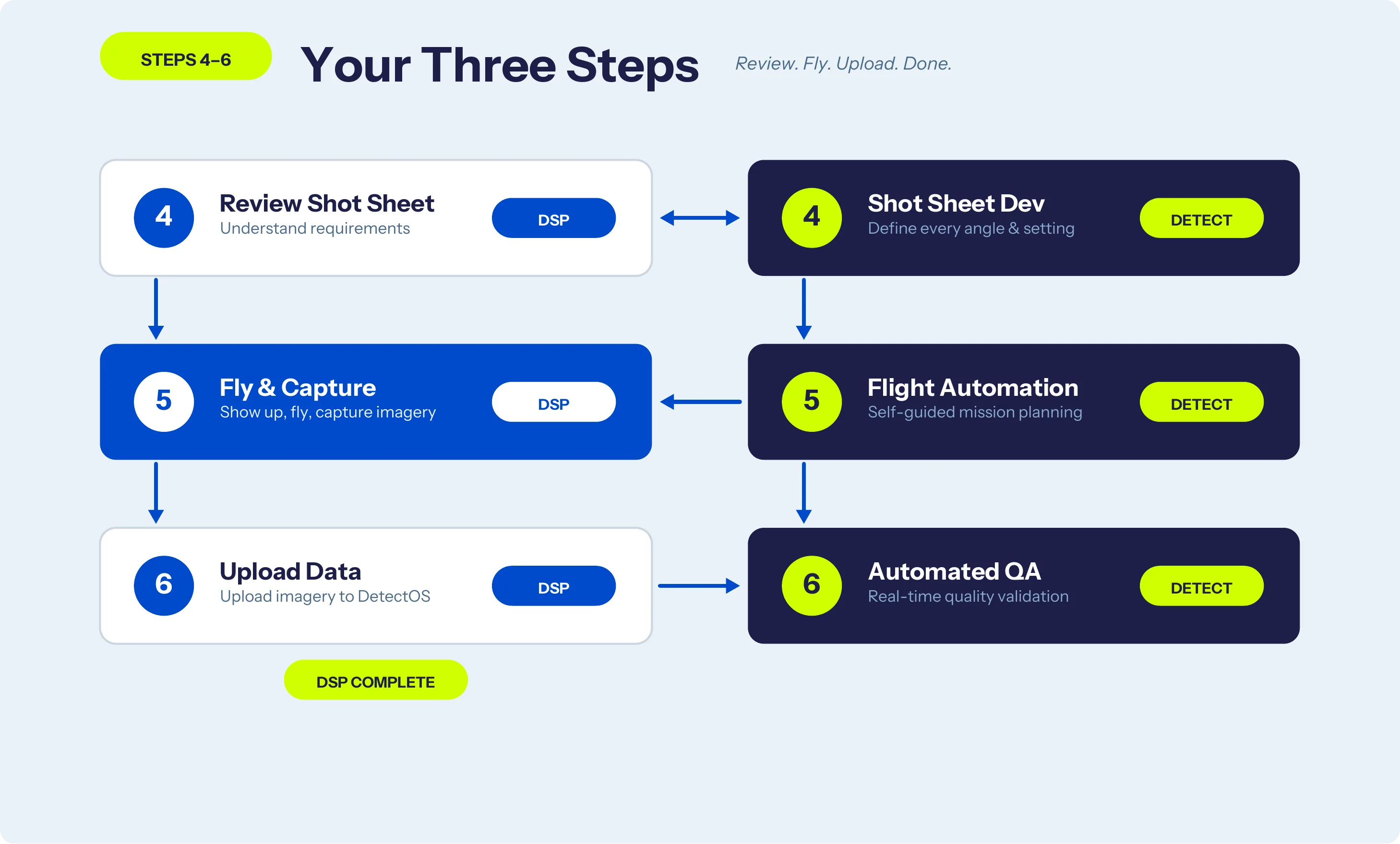
Step 4: Shot sheet development — Detect builds 3D digital shot sheets that define every required angle, position, and camera setting for each structure type. You review the sheet so you know exactly what you're capturing. This is what eliminates the "fifth pilot problem" — every pilot on your team follows the same standardized capture spec. No guesswork. No variability.
Step 5: Fly & capture — Detect provides automated flight plans. You show up, execute the mission, capture imagery. Self-guided paths handle coverage and consistency. The automation doesn't replace your piloting skill — it ensures that every structure gets the same complete coverage regardless of who's flying.
Step 6: Upload & automated QA — You upload imagery to DetectOS. The system validates data quality in real time: resolution, angle coverage, completeness, focus. If something's wrong, you know before you pack up the truck. This single step is what separates DSPs that protect their margins from DSPs that absorb reflights. Bad data caught on-site costs you minutes. Bad data caught in post-processing costs you a full remobilization.
After upload, your work is done.
No post-processing. No image tagging. No report writing. No waiting weeks for feedback. Upload, confirm QA passes, move to the next site.
Why this matters for scaling: These three steps are the same whether you have one pilot or twenty. The shot sheets and flight plans standardize everything. Adding crew members doesn't add variability — it adds capacity.
Steps 7–9: After You Upload
You're out of the picture. Here's what happens to your data.
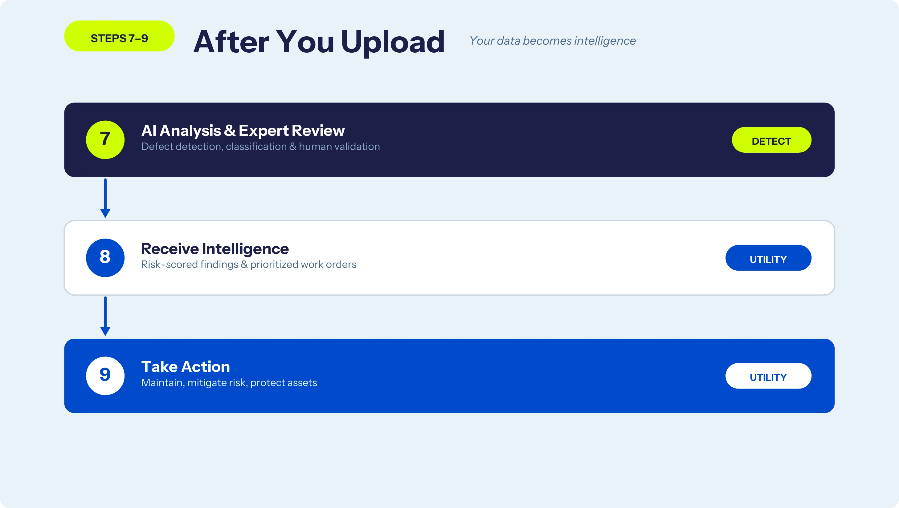
Step 7: AI analysis & expert review — DetectOS processes every image through AI-powered defect detection. Corrosion, cracked insulators, loose hardware, vegetation encroachment — classified and severity-ranked. Then human engineers validate every finding. No unreviewed AI output reaches the utility.
Step 8: Utility receives intelligence — Risk-scored findings, annotated imagery, and prioritized work orders delivered through DetectOS. Ready to plug directly into the utility's maintenance systems.
Step 9: Utility takes action — The process doesn't end with a report. It ends with crews deploying to replace hardware, trim vegetation, and prevent outages. Your data drives real maintenance outcomes on the grid.
Why this matters for your reputation: When the final deliverable is this clean, utilities don't come back with complaints about your data quality. They come back with more work.
How This Workflow Protects DSP Margins on Fixed-Fee Contracts
This workflow exists because the old way doesn't scale. Manual flight planning, manual QA, inconsistent capture standards, and weeks-late feedback loops destroy DSP profitability on utility contracts. The fix isn't working harder — it's having a structured process where every step has a clear owner and the steps that kill your margins are automated.
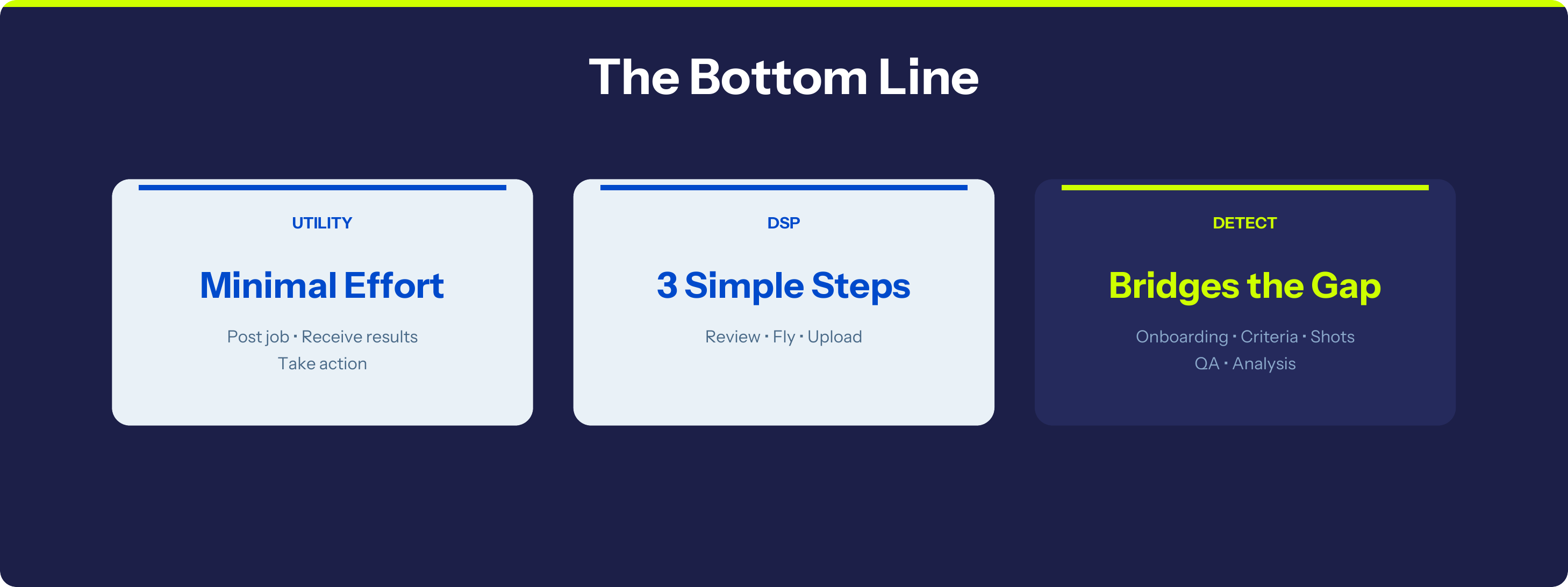
For DSPs, that means three things:
- Your scope is defined. Review the shot sheet, fly the mission, upload the data. Everything else is handled. No scope creep, no ambiguity, no unpaid work.
- Your quality is consistent. Automated shot sheets and flight plans mean every pilot captures utility-grade data. You scale your team without scaling your problems.
- Your margins are protected. Real-time QA catches issues on-site. No reflights. No rework. No warranty jobs eating into your fixed-fee contracts.
Download the Full Utility Inspection Workflow
Get the complete 9-step swim lane chart as a one-page PDF. Print it, share it with your pilots, bring it to your next utility pitch.
Ready to stop the rework? The Data Quality Program equips your team with automated shot sheets, self-guided flights, and real-time QA — so every mission delivers utility-grade data the first time.
Learn about the Data Quality Program →