
Asset Inspection Software: What It Is, What It Must Carry, and How to Choose It
Most tools sold as asset inspection software digitize a clipboard. That works until the evidence is 65,000 images from one drone campaign. Here is what the category actually has to carry, from the first flight to the next cycle, and a four-question test for finding the layer your program is missing.
Asset inspection software is the category of tools that plan field inspections, capture asset condition data, and turn it into findings a crew can act on. The useful test is not the label but what a tool carries: from capture, through quality grading, analysis, and expert verification, into a structure-level record your EAM and GIS can read.
- The label hides the difference. The category runs from checklist apps to inspection intelligence platforms; what separates them is which stages of the inspection record each one carries.
- Imagery is now the evidence, and the ratios are brutal. On one HVDC intertie, 122,714 images produced 1,270 flagged frames and one line-critical defect (Detect Data Quality Program, 2026).
- Capture quality sets the ceiling. Sharp imagery keeps 100% of Detect's 258-type defect catalog assessable; blurry imagery keeps 7% (Detect Data Quality Program, 2026).
- For drone service providers, the software is margin. Software-checked capture cuts rework from 15-25% of delivered imagery to 3-7% within two campaigns (Detect, State of Utility Drone Inspections 2026).
- Classify before you buy. The Capture-to-Decision Test - four questions about evidence, quality gate, verification, and output - tells you what a tool really is.
- What is an asset inspection?
- What is asset inspection software?
- What does asset inspection software have to carry?
- What are the types of asset inspection software?
- Why do photos outnumber findings?
- What should utilities look for?
- What should drone service providers look for?
- How do you choose asset inspection software?
- The bottom line · FAQ
What is an asset inspection?
An asset inspection is a structured check of a physical asset's condition - a pole, a tower, a span of conductor, a transformer, the hardware on any of them - documented so someone can act on it. It answers three questions: what is there, what condition is it in, and what has changed since the last time anyone looked.
That third question is the one most programs lose. A photo in a folder answers the first two for the person who took it. It answers the third for nobody, because it is not tied to a structure, dated against a baseline, or comparable to the frame from two years ago. The inspection happened; the record did not.
Two crews can inspect the same corridor and produce two records nobody can compare. Nothing about that breaks a rule. It just means the program bought photographs when it needed condition history - and that gap is what the software category exists to close.
What is asset inspection software?
Asset inspection software is any tool that helps a team assess the condition of physical assets and route what it finds into work. The category covers everything from a phone app that replaces a paper checklist to platforms that classify defects in drone imagery automatically and hand your EAM a ranked work queue.
That range is the problem. Two products carry the same label and share almost nothing: one records a lineman's observations, the other analyzes 65,000 images and returns 67 critical findings. Buying the wrong layer is how a utility ends up with digitized paperwork on top of an unreviewed photo archive - and how a drone service provider ends up re-flying a quarter of what it delivered.
So the useful question is not "which asset inspection software is best." It is "which stages of the inspection record does my program lack." That starts with knowing what the record has to carry.
What does asset inspection software have to carry?
Seven stages, in order: plan, capture, grade, analyze, verify, record, and work - then back to plan, because the next cycle is measured against this one. No single product covers all seven well. What matters is knowing which stages a tool carries and which it quietly leaves to you.
- Plan. Routes, shot sheets per structure type, and the structure list the campaign is checked against. Checklist and GIS apps do this well.
- Capture. Drone, truck-mounted camera, helicopter, and phone imagery - increasingly all four on one program. The software's job is to accept all of them into one record, not one at a time.
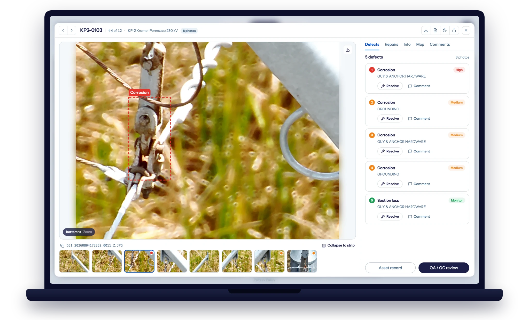
- Grade. Every image scored for sharpness, coverage, and structure association before analysis. This is the stage most products skip, and the one that decides everything downstream.
- Analyze. Defect classification across component classes, at a volume no crew can review frame by frame.
- Verify. An engineer signs off on what the AI flagged. Findings nobody signed are not findings; they are suggestions.
- Record. One structure, one condition history, every image and finding dated against it. This is the asset, not the photos.
- Work. Findings leave as records the EAM and GIS can consume - severity, location, structure ID - and become work orders without re-keying.
The mature stack in a utility program is not one tool. It is an EAM system of record, a GIS backbone, and an inspection intelligence layer feeding both - the arrangement laid out in our guide to utility asset management software. This article stays on the inspection layer: the stages between the camera and the work order.
What are the types of asset inspection software?
Four, split by the evidence each one reads: checklist and forms apps, GIS field tools, EAM and CMMS inspection modules, and inspection intelligence platforms. The first three organize what people observe and where. The fourth reads what cameras capture, which is where inspection volume now lives. Generic inspection management software and field inspection apps sit in the first tier - useful for audits and compliance walks, silent on imagery.
We compared the four categories against utility-specific criteria, with named examples in each tier, in the companion guide to the best AI inspection software for utilities. The short version for this article: the tiers are complements, not rivals, and the buying mistake is expecting fourth-tier work from a first-tier tool.
Ask where a tool keeps a drone photo. If the answer is "attached to the record," it is a checklist or EAM tool - the photo is a receipt. If the answer is "graded, analyzed, and tied to the structure," it is inspection intelligence - the photo is evidence.
Why do photos outnumber findings?
Because inspection evidence became imagery, and imagery arrives at ratios no manual process was designed for. Three real campaigns show the shape of it. On a newly commissioned ~250-mile HVDC intertie of ~2,600 lattice towers, 122,714 images were screened in 30 days by three people; 1,270 were flagged for expert review, and one verified finding - a clevis bolt with its cotter key missing - averted a $1M+ forced outage the following winter (Detect Data Quality Program, 2026). On a new 345kV line, 65,701 images across 927 structures produced 45,335 findings, 67 of them critical, with 76% of the criticals in one construction segment (Detect and CompassData, 2026). On two 40-year-old wooden H-frame lines, a 3-person crew covered all 96 structures in one field day and flagged 55 high-risk conditions (Detect case study, 2026).
122,714 images. 1,270 flagged. One defect worth $1M+. Roughly a hundred frames for every finding worth a second look, and a thousand for the one that mattered. A tool that stores photos handles the first number. Only a tool that grades, analyzes, and verifies gets you to the last one. Source: Detect Data Quality Program, 2026.
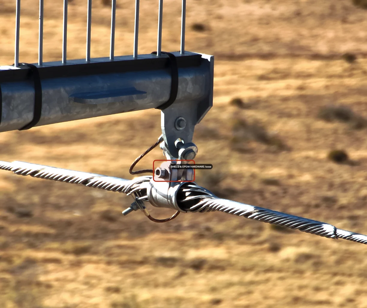
The ratio only holds if the frames are assessable. Detect's Data Quality Program measured the ceiling on its 258-type, 19-class transmission defect catalog: sharp capture keeps the full catalog assessable, soft capture 69%, blurry capture 7% (Detect Data Quality Program, 2026). The fastener- and splice-level conditions that fail first are exactly what soft frames hide. What a utility should write into its photo spec to protect that ceiling is the subject of the decision-grade photo standard; the point for a software buyer is simpler. A tool that measures capture quality before analysis protects the whole downstream investment. A tool that accepts whatever arrives digitizes the blind spot.
What should utilities look for in asset inspection software?
Utility inspection software should be judged on five things: accuracy reported by defect class, capture quality graded at ingest, engineer review of every flagged finding, risk-based ranking, and a clean handoff into the EAM and GIS systems the utility already runs. Weighting those criteria is its own discipline - the grid inspection AI scorecard covers it - so two deserve the hard questions in a demo.
- Accuracy by defect class, not overall. A platform can post a strong average while missing the two classes that drive your outage history. Ask for per-class numbers on the components you care about, and ask who verified them. The seven checks before you trust AI findings start there.
- What leaves the system, in what shape. Findings that arrive as PDFs get re-keyed or ignored. Findings that arrive as structure-keyed records with severity and location become work orders. The Asset-Record Contract is the specification for that handoff.
The stakes are set by the capital plan. U.S. utility CapEx is on pace to roughly double, from $0.7 trillion in 2015-2024 to a projected $1.4 trillion in 2025-2030 (Morningstar DBRS, cited in Detect's State of Utility Drone Inspections 2026). Every new build becomes an asset that needs a condition record from day one - and the software you choose decides whether that record starts on day one or gets reconstructed years later from a folder.
What should drone service providers look for?
Drone inspection software for a service provider has one job before any other: protect the deliverable, because rejected imagery is what erases margin. Across observed programs, 15-25% of delivered imagery needs rework on ad-hoc workflows, and roughly 30% of ad-hoc imagery is rejected before analysis (Detect, State of Utility Drone Inspections 2026).
Most of that rework is not pilot skill. GPS misassociation - imagery tagged to the wrong structure - accounts for 35% of it, and missing component coverage for another 30% (same report). Software that validates structure association and coverage in the field turns each of those from a re-fly into a re-shoot before the crew leaves the site. Programs that standardize on software-checked capture bring rework down to 3-7% within two campaigns; the program-level fix is in our guide to cutting inspection rework.
One more reason the choice matters: utilities increasingly ask for a measured rework rate when they evaluate drone vendors. Software that produces that number turns a quality process into bid collateral.
How do you choose asset inspection software?
Run every candidate through the Capture-to-Decision Test - four questions that classify any tool honestly, whatever its label says.
- What evidence does it ingest? Forms and observations, or imagery at fleet scale - drone, truck, helicopter, and phone in one place?
- Is capture quality measured before analysis? If nothing grades sharpness, coverage, and structure association at ingest, the assessability ceiling applies silently.
- Who verifies the findings? AI alone, people alone, or AI screening with engineer sign-off - the hybrid is what produces findings a reliability engineer will put their name on.
- What leaves the system? A photo archive, a PDF, or a risk-ranked, structure-level record your EAM and GIS can read. The output tells you which type you are really buying.
A tool that answers "forms, no gate, people alone, a PDF" is a checklist app - fine, if that is the layer you need. If your program captures imagery, the gaps in answers two through four are where the money leaks. Selecting the operator who flies the program is a separate decision with its own criteria; selecting the capture method is another, covered in utility inspection data capture methods.
The bottom line
Asset inspection software is a category with a wide label and a narrow test. Checklist apps, GIS tools, and EAM modules organize what people report. Inspection intelligence platforms make the imagery itself the evidence - graded, analyzed, verified, and recorded against the structure. If your program's photos outnumber its findings by a hundred to one, the missing layer is that one.
The payoff is not the first report. It is the record: a condition baseline every future inspection is measured against, starting from the day the asset is commissioned. That is the layer Detect builds. DetectOS turns utility inspection imagery into decision-grade findings, with capture quality measured up front, an engineer on every flagged defect, and one record per structure that your EAM and GIS can read.
See what your current software is leaving in the folder
Send Detect a recent inspection set. The free audit grades assessability and association image by image - the first honest measure of how much of what you paid for can actually be acted on.
Book a free audit →