
Ten Months in the Field: From a Cardboard-Box Prototype to a Production Capture Unit
How Detect's operations technology team built a vehicle-mounted utility pole data collection system - and why the hard problem was never the camera.
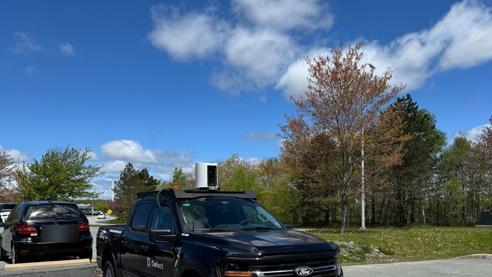
- Build each prototype to answer one question. Every rig existed to settle a single go/no-go: can road-speed imagery be assessed, can it be matched to the right pole, can crews run it every day.
- Association, not capture, was the bottleneck. Proximity matching on GPS failed in dense corridors and against records that were off by several meters. In Detect's State of Utility Inspections 2026 report, GPS misassociation accounted for 35% of imagery rework.
- Lock the camera. Shutter speed, ISO, focus, and exposure are fixed for the shift, because capture quality decides assessability: sharp imagery is 100% assessable against the 258-type defect catalog, blurry imagery 7% (Data Quality Program asset-owner report).
- Procedure is half the product. Pre-shift checklists, dual logging, and a review gate did as much for data quality as any model.
- Routing drives throughput. Separating fast roadside runs from slow off-road spans is how crews average 1,000+ poles a day.
One idea runs through the ten months: a capture system is a bookkeeping system with a camera attached. A frame is only worth what the record it lands in can prove.
- What were we trying to prove?
- Month 1: a camera on a cardboard box
- Month 2: which pole did we photograph?
- Month 4: a rigid mount and better association
- Month 6: crews, every day
- Month 10: the camera triggers itself
- What the system is today
- What we would tell another team
- FAQ
What were we trying to prove?
Two things. Can distribution structures be assessed from images captured at road speed, and can each image be assigned to the correct structure at that speed? Both had to be yes for the system to matter.
The scale explains why. The United States alone has about 180 million utility poles (US Department of Energy). No utility has a reliable, affordable way to collect usable condition data on each one. So we built every prototype as a proof of concept with one job: capture imagery good enough to assess each individual pole.
| Month | Rig | Question it had to answer | Capability added |
|---|---|---|---|
| Month 1 | Cardboard box | Can road-speed imagery be assessed? | Stabilized capture |
| Month 2 | Plywood bench | Can we identify which pole an image belongs to? | GPS, compass, mapping |
| Month 4 | Rigid mount | Does the system hold up in the field? | Live image-to-pole matching |
| Month 6 | Daily operations | Can crews run it every day? | 1,000+ poles a day |
| Month 10 | Custom controls | Can the camera trigger itself? | Pole detection, auto-capture |
Month 1: can a camera on a cardboard box capture usable pole imagery at road speed?
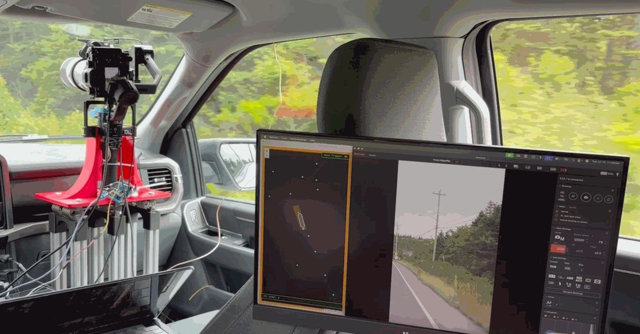
Yes. The first rig was a stabilized camera sitting on a cardboard box in the passenger seat of a pickup. It was built on a small budget with one goal: prove whether road-speed photos could capture high-quality distribution pole imagery. This was the first go/no-go gate. If we could not capture the images, nothing else mattered.
It worked, and it worked from inside the cab. That let the proof of concept stay indoors for months and deferred weatherproofing. What it did not prove was whether we could associate each image with the correct pole at road speed. That was the second prototype's job.
Month 2: can we tell which pole we photographed?
Not reliably, at first. Version two upgraded to a plywood bench, a tethered laptop, GPS, a compass, and rough mapping code written in the truck between test passes. Once we checked the automated matches against reality, they fell apart.
Proximity matching worked on open rural roads. It broke in dense corridors with staggered spans, poles on both sides of the road, and utility records that were off by several meters. That was the realization that reshaped the project: we thought we were building a camera system. We were building a bookkeeping system that happened to have a camera attached.
We thought the hard part was photographing the pole. The hard part was knowing which pole we had photographed. It is not a vehicle-only problem: in Detect's State of Utility Inspections 2026 report, GPS misassociation accounted for 35% of the rework on delivered drone imagery.
Why is GPS alone not enough for image-to-pole association?
Because position tells you where the truck was, not what the camera saw. We added real-time polygon buffers built from GPS position and heading, which fixed most matches on the road. Some could not be settled in the truck. So we built a review step into the application. The operator confirms the association before imagery is sent for analysis, and only frames bound to a verified structure enter the pipeline. That gate is how we avoid the pattern the wider industry lives with, where 15-25% of delivered imagery is reworked before AI can use it.
Month 4: does a rigid mount fix association?
Mostly. The plywood bench gave way to a rugged aluminum mounting system. A fixed platform meant we could track the camera's movement precisely, which made the heading reliable, and reliable heading is what association depends on.
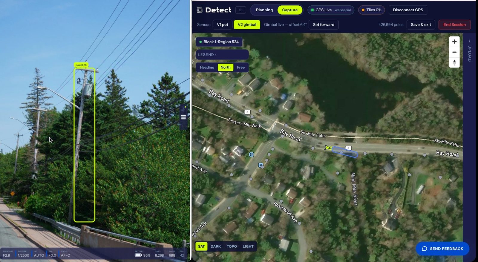
With it, images bound themselves to poles while the truck was moving, and the cab screen became a live audit of every match. A few association problems persisted, all from conditions outside the truck: bad records, unusual spans, poles set well back from the road.
Month 6: can crews run it every day?
Yes, once procedure caught up with hardware. With capture quality and association answered, the prototype went into full operations, and the non-technical problems showed up. Sensors, lenses, and batteries needed pre-shift checks or capture hours were lost. Local and cloud logging had to run in parallel so a cellular dead zone cost nothing. Routing had to keep path-planning efficient across the fleet.
Throughput came from routing and procedure, not hardware. Separating fast roadside runs from slow off-road spans is why our crews average 1,000+ poles a day, with the best days above 2,000. It is the least intuitive lesson of the ten months and probably the most transferable.
Month 10: can the camera trigger itself?
Yes. By month ten we had replaced off-the-shelf camera controls with our own PID controller. We added on-board computer vision for pole detection and motion tracking, and logged position and heading for every frame. The camera now shutters itself when a pole is in frame, which removes the human timing errors that used to cost us data.
We also locked the parameters that govern assessability: shutter speed, ISO, focus, and exposure. Imagery stays identical regardless of who is driving. Leave those settings to in-the-moment judgment and quality drifts. Lock them and it holds.
Capture quality decides what the AI can assess. In Detect's Data Quality Program asset-owner report, sharp imagery was 100% assessable against the 258-type, 19-class defect catalog, soft imagery 69%, and blurry imagery 7%. A blurry frame is not a slightly worse frame. It is a defect the AI cannot see.
What does the vehicle capture system look like today?
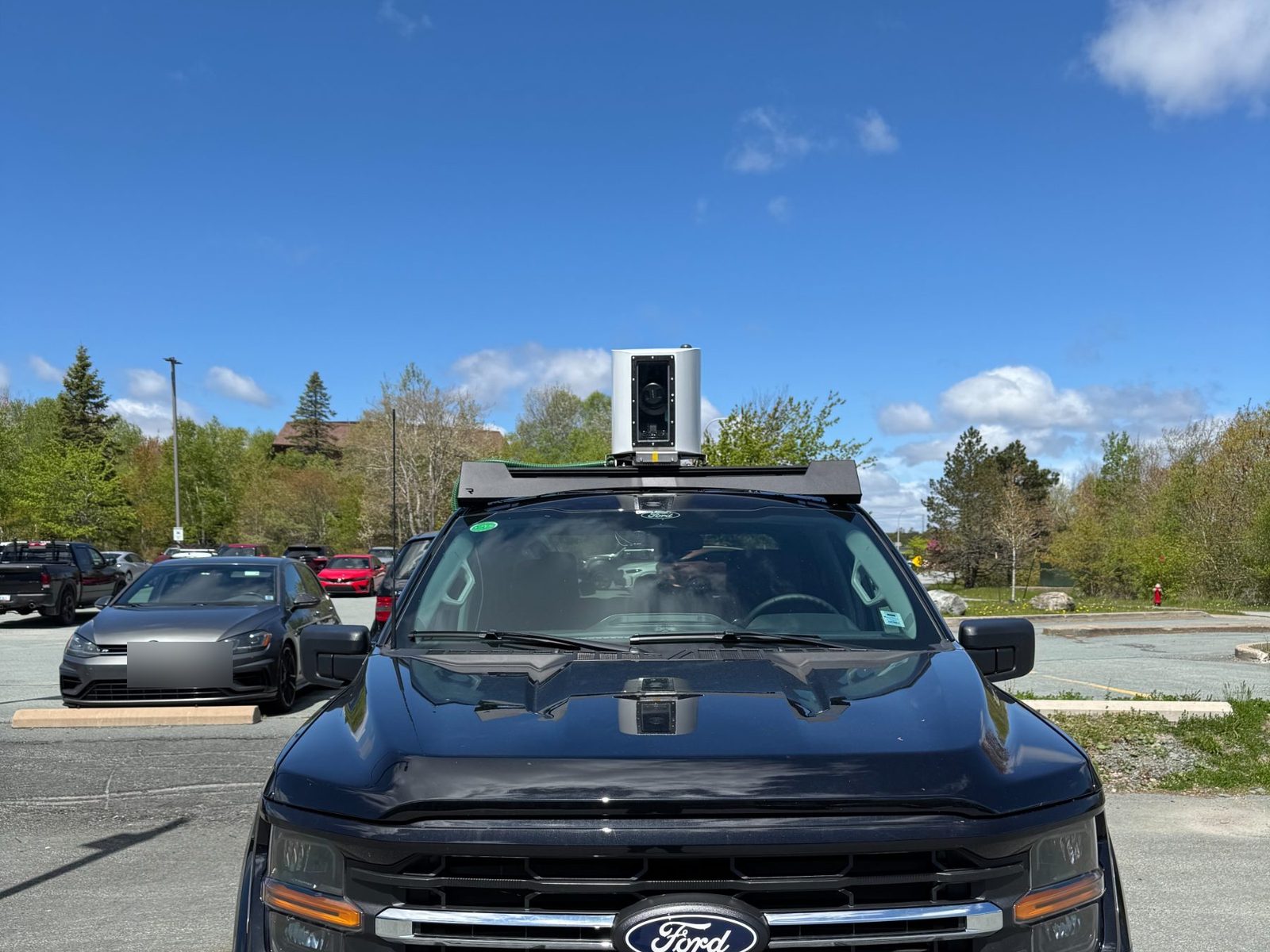
A sealed, roof-mounted industrial gimbal with a high-quality image sensor, machine-vision cameras, GNSS for position, and encoders for heading. Everything that decides whether a frame is usable runs on an on-board computer, which binds each frame to a single distribution structure as it is taken.
Watch: the roof-mounted unit running in the field.
What a shift looks like
- In the truck: one person, driving. Capture is automatic. The operator supervises, resolves ambiguous targets, and flags access problems.
- On the screen: a live block map with per-pole status - captured, pending, or reshoot needed - so a block is finished knowingly rather than hopefully.
- Off the shift: graded imagery grouped by pole into a review queue, plus proposed new structures, corrected coordinates, and phantom poles flagged for retirement.
- Throughput: 1,000+ poles a day on average. Restricted-access structures are reserved for drone and mobile capture.
What is on the vehicle
| Component | What it is for |
|---|---|
| Roof-mounted enclosure | Sealed and weatherproof, with its own cleaned optical path. The camera never shoots through a cab window, and no passenger seat is occupied. |
| Primary camera on a gimbal | Produces the assessable frames. Stabilized, aimed automatically, and run with locked settings for the whole shift. |
| Machine-vision camera | Watches the corridor continuously at high frame rate, so structures are found early enough to aim at. |
| GNSS and derived heading | Position, plus a camera bearing derived from course-over-ground and the measured camera offset rather than a magnetometer. |
| In-cab compute | Runs detection, aiming, grading, and the association solver locally. The uplink ships data; it is never in the decision loop. |
| Controller and live view | In-house camera control with the assessability-critical settings locked, alongside the live block map. |
| Dual logging | Continuous upload mirrored to local storage in the vehicle, so cellular dead zones cost nothing. |
What it can do today
- Find and capture poles automatically at normal road speed, including structures that appear in no record.
- Bind every frame to a single structure ID as it is shot, with position and heading retained as evidence.
- Grade each frame on sharpness, obstruction, and coverage, and flag anything below standard for an immediate reshoot.
- Return records corrections: proposed new structures, corrected coordinates, and phantom poles flagged for retirement.
- Run a full shift with one person driving, finishing each block against a live per-pole status map rather than an assumption.
That output feeds the same review and reporting pipeline as our drone and mobile capture. A truck-captured distribution pole inspection lands in the same structure record as one flown by a pilot.
See what the capture standard does for your data
DetectOS reads the imagery you already collect - vehicle, drone, or ground. It finds defects against a 258-type catalog and returns expert-verified findings bound to the right structure. Send us a recent inspection and we will grade its capture quality and association against the standard above.
Book a free audit →