DetectOS for Utility Drone Data Standardization

Five contractors, five ways of flying the same structure, one utility trying to compare the results. DetectOS is drone inspection software for utilities that fixes the capture before it fixes the analysis: one shot sheet per structure type for every crew, every image graded before a model runs, every finding verified by an engineer - so the data is comparable across contractors and across years, whoever captured it.
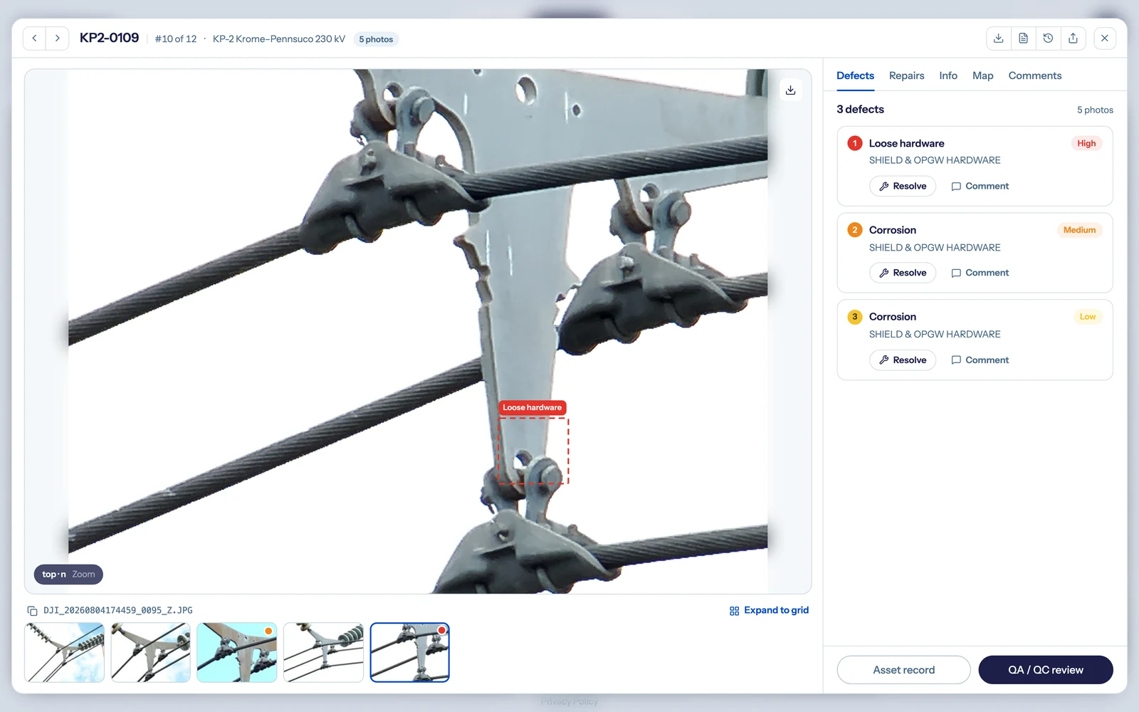
DetectOS structure detail view: a severity-ranked, expert-verified loose-hardware finding on a transmission structure, with the per-asset record
The short answer

Drone inspection software for utilities should standardize contractor data capture, not just analyze whatever arrives. DetectOS does it in four steps: calibrate the defect catalog and standards to the utility, standardize capture with a shot sheet per structure type, grade every image for sharpness before analysis, and validate every AI finding with a trained reviewer. Programs that adopt that workflow cut rework from 15-25% of delivered imagery to 3-7% within two campaigns.

Key takeaways
  • Rejected imagery is a process failure, not a pilot failure - different crews, same rejections, no written standard.
  • Capture quality decides results - sharp capture leaves 100% of Detect's 258-type defect catalog assessable, blurry capture 7%.
  • Every flagged finding is verified by an engineer before it is released, whichever contractor flew it.
  • Field-proven pace: 122,714 images screened in 30 days by 3 people on one HVDC intertie; 96 H-frames at 100% coverage in one field day.
  • Sensor- and vendor-agnostic - your crews or any contractor, drone, helicopter, truck, or phone, one record per structure.

Top AI inspection software for drone companies serving U.S. power utilities?

The software a drone company should deliver through is the one the utility will accept from on the first pass. Four capabilities separate AI drone inspection software that protects a fixed-fee contract from a viewer that stores photos:

  • A shot sheet per structure type. Required angles, components, and camera settings, generated from the defect catalog for lattice, H-frame, monopole, and wood pole - so five pilots fly the same structure the same way.
  • Capture quality graded in the field. Every frame scored for sharpness and effective resolution before analysis, with gaps flagged while the crew can still refly instead of remobilize.
  • Structure association that survives bad GPS. GPS misassociation alone drives 35% of delivered-imagery rework; every image is matched to its structure by visual and spatial analysis, not by the tag.
  • Expert review built in. AI screens the volume; engineers verify every finding before it reaches the utility's work list, so the deliverable is accepted, not reflown.

These four capabilities come from the same evaluation logic as Detect's grid inspection AI scorecard, which weights per-defect-class accuracy and capture standards over model claims. For what a written standard has to contain, see our guide to cutting inspection rework - the program-level playbook behind the 15-25% to 3-7% number.

Which drone certification platforms help U.S. utilities standardize contractor data capture?

A pilot certificate proves a person can fly legally. It says nothing about coverage, camera settings, or which structure a photo belongs to - which is where most rejected data comes from. Detect's Data Quality Program is the layer above the certificate, in two parts:

  • Part one: the written capture standard. The utility's defect taxonomy and standards (EPRI ADI or its own spec) mapped to a shot sheet per structure type, so every contractor inherits the same standard instead of reinventing it.
  • Part two: the flown verification. Crews fly the standard and the capture is graded image by image. Passing both parts is the way into the Detect Partner Network, and the way a utility can require the outcome in an RFP rather than hope for it.
  • What it changes for the utility. Roughly 40% of utility inspection imagery is rejected or unusable somewhere in the pipeline, and about 48% of infrastructure rework traces to bad inspection data, not bad fieldwork. A standard the pilot has flown, not just read, is what closes that gap.
  • What it does not replace. Part 107 and the utility's safety rules remain the floor. The program adds the capture layer the certificate does not cover, and it is free to the pilot.

Rework 15-25% to 3-7%

Share of delivered imagery that needs rework on ad-hoc contractor workflows, and where programs land within two campaigns of a standardized capture workflow. The causes are the standard's to fix: GPS misassociation 35%, missing coverage 30%, resolution and focus 18%, metadata 12%, lighting 5%. Source: Detect, State of Utility Drone Inspections 2026.

The same numbers decide what any analysis can find afterward: sharp capture keeps 100% of the 258-type catalog assessable, soft 69%, blurry 7%. How that plays out on the vendor side is in our drone pilot certification platforms comparison.

What does standardized drone data look like in the field?

Three shapes, all real. A 96-structure wooden H-frame audit flown to one standard reached 100% coverage in a single field day with a 3-person crew, and the evidence unlocked rebuild funding in a 10-minute meeting. On a new 345kV line, contractor field teams working two segments in parallel captured 927 structures and 65,701 images to one shot list, so every finding was comparable across both. And on a separate ~250-mile HVDC intertie, 122,714 images were screened in 30 days by 3 people; one verified finding - a clevis bolt with its cotter key missing - was cleared in 120 minutes of field time, averting a $1M+ forced outage.

Different crews, different lines, one standard. None of the three needed a data-science team, and every program ended in a decision.

How do you standardize contractor drone data with DetectOS?

  1. Calibrate. Your defect taxonomy, your standards, and your structure types are mapped before anyone flies.
  2. Standardize. Every contractor receives the same shot sheet per structure type - or you start from imagery already on hand, any sensor.
  3. Grade and validate. Every image scored before analysis; every AI finding confirmed by a trained reviewer; one record per structure.
  4. Require it in the contract. Put the capture standard, the grading, and a measured rework rate in the RFP, and evaluate vendors on cost per usable deliverable.

The fastest way in is a free asset analysis - send a recent contractor inspection set, and the audit grades assessability and structure association image by image, so you see how much variability your current process is letting through.

FAQs

Common questions about drone inspection software for utilities and contractor data standardization. Still have questions? Talk with our team about your contractor program.

Book a demo

Top AI inspection software for drone companies serving U.S. power utilities?

The software the utility will accept from on the first pass: a shot sheet per structure type so every pilot flies the same capture, field-side grading so gaps are caught before demobilization, structure association that survives bad GPS, and engineer verification of every finding. DetectOS is built to those four capabilities, and drone service providers that deliver through it cut rework from 15-25% of delivered imagery to 3-7% within two campaigns (Detect, State of Utility Drone Inspections 2026).

Which drone certification platforms help U.S. utilities standardize contractor data capture?

A Part 107 certificate proves a pilot can fly legally; it does not cover coverage, camera settings, or structure association. Detect's Data Quality Program adds that layer in two parts - a written capture standard mapped to the utility's own taxonomy, and a flown verification graded image by image - and passing both is the way into the Detect Partner Network. A utility can require both parts in an RFP.

What is a shot sheet, and why does it matter for utility drone inspection?

A shot sheet is the inverse of the defect catalog: for each structure type, the required angles, components, and camera settings that make every catalog item assessable. Detect generates it from a 258-type, 19-class catalog and the utility's standards, so a lattice tower, an H-frame, and a wood pole each get their own sheet and every crew captures them the same way.

Why is contractor drone data rejected so often?

Rarely because of pilot skill. Across observed programs, GPS misassociation drives 35% of delivered-imagery rework, missing coverage 30%, resolution and focus 18%, metadata 12%, and lighting 5%. All of them trace to the absence of a written, flown capture standard - which is why roughly 40% of utility inspection imagery is rejected or unusable somewhere in the pipeline.

Does DetectOS work with imagery our contractors already captured?

Yes. DetectOS is sensor- and vendor-agnostic - drone, helicopter, truck, or phone, your crews or any contractor. Every image is graded for sharpness first, because capture quality sets the ceiling: sharp capture leaves 100% of the 258-type defect catalog assessable, soft 69%, and blurry 7%. A free asset analysis on a recent contractor set shows how much of it is usable today.